Life sucks a lot less when you add mountain air, a campfire and some peace and quiet. —Brooke Hampton

We don’t inherit the earth from our ancestors, we borrow it from our children. —Native American proverb

In matters of style, swim with the current; in matters of principle, stand like a rock. —Thomas Jefferson

Nature is the art of God. —Dante Alighieri

Wednesday, April 11, 2018

Anza Borrego Goat Canyon Trestle Hike


The Goat Canyon Trestle is an Anza Borrego treasure in the desert near the California-Mexico border. The trestle is part of the San Diego and Arizona Railroad and was built by John Spreckels in 1919. It connected San Diego with Yuma, navigating the difficult terrain through a series of 17 tunnels. The Goat Canyon Trestle was built in 1932 to replace tunnel 15 that was damaged from an earthquake and still stands today at 600-ft long by 200-ft tall. According to Wikipedia, the Goat Canyon trestle is the largest curved wooden trestle in the world. Wood was used instead of metal to build the trestle because metal would fatigue with the extreme temperature changes in Carrizo Gorge. The railroad was known as the "The Impossible Railroad" when it was completed.

You can read more about the history of the "Impossible Railroad" in the book "San Diego and Arizona Railway: The Impossible Railroad" by Dr. Reena Deutsch.


There are 3 ways you can hike to the Goat Canyon Trestle. The first way is an 8 mile strenuous round trip hike over the Jacumba Mountains with an ascent of about 2100 feet and a decent of 2400 feet while boulder hopping.  The second, is a 20 mile round trip hike along the tracks from the city of Jacumba.  And the third way, a 10 mile round trip hike along the tracks from the old Dos Cabezas railroad siding located off of Sweeney Pass Road/Imperial Highway in Anza Borrego State park.

The most popular way to the trestle is by way of Jacumba.  Both hikers and mountain bikers use this route.  For our hike, we chose to hike the 4 miles over the Jacumba mountains to the trestle and then return following the tracks to the Dos Cabezas Water Tower. Total hike was approximately 15 miles. We choose these routes because both routes offered amazing views of the desert along the trail and railroad track.

We decided to camp at the trailhead and get an early morning start.


Campsite at trailhead.


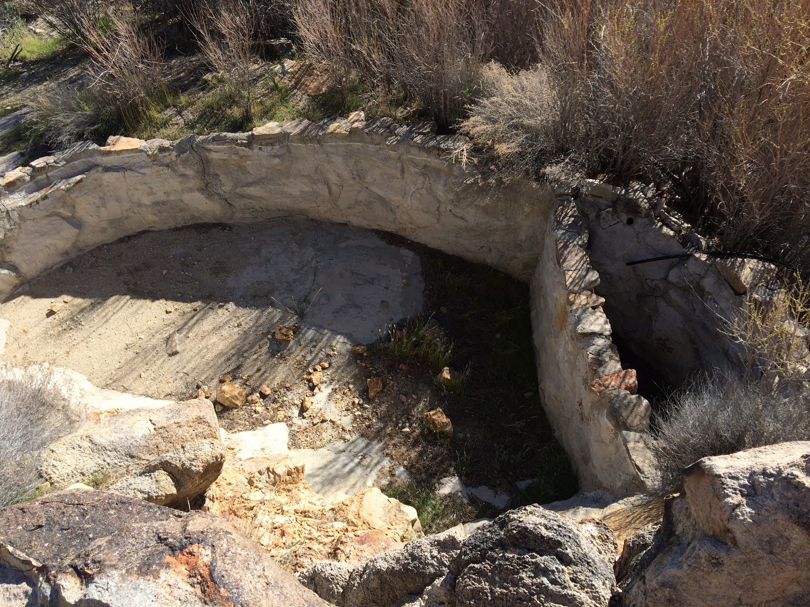
Our trail took us by an old water trough and the Mortero Palms Oasis. 


Mortero Palms Oasis


Note the blue speck in the center of the picture below just above the rocks.  This is our vehicle at the trailhead.


The trail was rough and rocky.  Both pictures below are looking back toward the trailhead.


The only section of the trail that was somewhat level.


In the picture below, the trail heads down over the rocks into the valley between the two hills.  At times, we were sliding down rock faces on our backsides. Sometimes it was hard to follow the trail over the rocks.


Here is our first look at the San Diego and Arizona Railroad in the distance.


After we rounded the rock outcropping in the above picture, we were able to see the Trestle below.


The above pictures of the trestle were taken above a 50 foot dry waterfall.  Below are a couple of pictures at the bottom of the waterfall looking up.  Someone hung a rope down the waterfall for assistance, but we used our climbing skills instead.

This is me pretending to use the rope.


My friend Jerry climbing on the waterfall.


Below is another view of the dry waterfall.  The yellow rope is just visible to the right of center in the picture.


The closer we got to the trestle the more impressive it looked.


You can see the Tunnel 15 entrance on the left in the foreground of both pictures below.  This is the tunnel that was destroyed by an earthquake in 1932.


The water tank on the hill below was used to gravity feed water to a sprinkler system installed on the trestle in case of fire.  Pretty ingenious.


After we had lunch in the shade of a tunnel it was time to head down the track.  Here are a couple of tunnels we went through.


Looking back at the other side of the above tunnel and the landslide blocking the entrance. You can see the rails in the foreground.


The pictures below show the age of the rails.

1930


1919


1926


1913

Here are pictures of a pair of train cars that are on the side of a hill.  Back in the day, if a car derailed they just pushed it off the side.


Here is a view of Carrizo Gorge from the railroad track.


An oasis in one of the gorges visible from the track.


And finally our destination, Dos Cabezas Water Tower, then a 2 mile hike to the truck.


Here are our hike statistics.

Trailhead to Trestle. Satellite view.


Trestle to Dos Cabezas Water Tower and truck,  Satellite view.


Elevation chart, trailhead to trestle.


Elevation chart, trestle to Dos Cabezas Water Tower and truck.


Some words of caution for anyone thinking of the Trestle hike:


  • Wear a good pair of hiking boots, preferable ankle high or higher to protect from twisting an ankle bouldering.
  • Wearing long pants protects you from thorns and scrapes from rocks.
  • Take gloves to protect your hands from rocks.
  • Take plenty of water, more than you think.  You will need plenty of water hiking in this terrain.
  • First aid kit in case you get tangled up with a cactus.

I prefer to hike in the spring because everything is greener and milder temperatures.

This was an awesome, yet strenuous, hike and I highly recommend it for anyone who likes trains, railroads, and the history of them.  

I hope you enjoyed the pictures and report.

Sunday, August 13, 2017

Death Valley Trip March 10-12 2017

Death Valley trip, three days and about 200 miles.

Our trip started in the town Trona and took us through Fish Canyon, Goler Wash and on to Barker Ranch. Barker Ranch is located at the western edge of Death Valley National Park. It was the last hideout of Charles Manson and where he and his clan were arrested. Here is a link to a news article for more information on Manson if you're interested.

After Barker Ranch we climbed Mengel Pass, then dropped down into Butte Valley.

From Butte Valley we entered Death Valley and then on to Silurian Valley, ending our trip in Baker.

This Fish Canyon Marker below reads: "Fish Canyon escape trail.  Where Manley and Rogers led the Bennett and Arcand families to safety from Death Valley in Feb. 1850".


Goler Wash trail.


Here is a picture of what the Baker Ranch looked like prior to 2009 when it was burnt down under mysterious circumstances. Before it was burnt down it was a great place to camp.


Below is what the Ranch looks like now. As you can see from the standing walls in the first picture, this was a nice and well appointed hideout and was complete with running water and indoor plumbing.

The building on the right was a storage shed. The left building was the ranch house.


Below is a picture of the ranch's bathroom. On the left is where the toilet was and on the right there is an outline of a small vanity where Manson was found hiding inside when the Sheriff came to arrest the clan.


After leaving Barker Ranch, we took the trail up to the top of Mengel Pass via Goler Wash. Mengel Pass was named after Carl Mengel, a historic prospector from the early 20th century.

Below is a picture of Carl Mengel's monument on top of Mengel Pass.  Carl's ashes and prosthetic leg, which he lost in a mining accident, are buried here.

Tradition says you can add a stone to the monument for good luck, which we did.


Here is a view looking down into Death Valley from Mengel pass.


After transversing Mengel Pass we headed to the Geologist Cabin to spend the night but someone had already claimed the cabin for the night, so we found a different desert cabin for the night. Here are a couple of pictures of our campsite.


Evening around the fire.


The cabin had some desert humor.


The next morning we went on a hunt for a hidden hideout or cellar which we did not find but we ended up in the same area where German tourists were stranded in 1996. Their remains were found in 2009. Here is a LINK where you can find more information on the German's and how their remains were found after 13 years. It's an interesting story.

A couple of pictures of the area.


Catch Basin


Throughout the trip we stopped at different desert cabins. Most of the cabins had mining claims associated with them, but most of the mine entrances are sealed. Some of the cabins were run down and falling apart, but others have been adopted by various groups or organizations and are well maintained.

Here are some cabin pictures (not in any particular order).


Some chairs were mounted in concrete on a hill behind one of the cabins with a view of Striped Butte.  What a great view!


Another cabin had a old bus. Based on the trail leading to the cabin, it must have taken a lot of work to get the bus to the cabin.


One of the many car chassis scattered around the desert.


Our Saturday night camping site was an old abandoned gypsum mine. Here is a picture with our great view.


On Sunday we visited some more cabins. which are pictured above, and some mines pictured below.


Trails to a couple of different mines.


One of the few open mine shafts. The trail to the shaft is 15 to 30 minutes from the main road and requires a high clearance 4X4. Because of it's remoteness the shaft is left open. The shaft is about 30 feet deep and about 20 feet long.


The mine pictured below had a lot of wooden infrastructure and in it's time must have been very active.


The following pictures are of another interesting mine with a lot of mining equipment and buildings. The background building is the mine residence.  The building in the foreground is where they processed the ore.


Inside the residence the floor has collapsed by the couch.  The top invoice in the box (in the foreground) is dated 1999. Not very long ago as mines in the area go.


The processing shed had a trough running the length where they processed some of the ore and unlabeled chemicals laying around. Nothing to mess with.


Repurposed ore grinder located above the processing shed.


Tractor located next to mine entrance.


One of our stops was Warm Springs Camp. The real shame is that the Park Service did not use the place as an annex or maintain it after it was donated. It was a beautiful complex, but now the buildings have been vandalized and because of the proximity to water, the walls are covered with wasp's nests.  There are at least three separate buildings and a swimming pool.


I've heard stories of people feeding coyote's along the side of Death Valley's roads and here is one. If you stop the coyote will approach the car hoping for a handout.  We were not obliging.


And finally, this is a screen shot of our trips track.  I hope you enjoyed this report.